You’ll find college campus digital navigation aids essential for a seamless student experience. Leveraging Bluetooth LE and Wi-Fi, apps like Navigine offer precise indoor positioning and interactive maps. These tools don’t just help you find your way; they integrate with campus services for hassle-free interactions. Administrators use them for real-time tracking of resources, optimizing energy usage, and improving campus layouts through movement analytics. With a user-friendly interface and customizable settings, you’ll experience efficient navigation and enhanced connectivity. Dive deeper and you’ll discover how these technologies are transforming modern educational environments.
Key Takeaways
- Utilization of apps for real-time indoor positioning using Bluetooth LE and Wi-Fi.
- Interactive campus maps are available for intuitive and easy navigation.
- Integration with campus services for streamlined communication and efficient interaction.
- Real-time tracking and wayfinding to reduce confusion and tardiness.
- Movement analytics for optimized campus layouts and resource allocation.
Navigation Inside Campuses

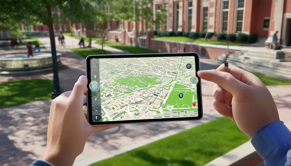
Getting around inside college campuses has become much more manageable thanks to digital navigation aids like the Navigine app, which leverages real-time location tracking. By utilizing technologies such as Bluetooth LE and Wi-Fi, the app provides precise indoor positioning, allowing you to navigate complex campus buildings effortlessly. Interactive campus maps available on your smartphone or digital displays strategically placed around the campus offer a wayfinding solution for colleges that’s both intuitive and efficient.
With real-time information at your fingertips, you can easily find the quickest route to your next class, the nearest restroom, or even a quiet study nook. This technology isn’t just for students; freshmen, guests, and professors also benefit immensely. Freshmen can especially find solace in stress-free wayfinding during their initial days, while guests visiting for events won’t feel lost in sprawling campuses. Professors can save valuable time by avoiding unnecessary detours.
The movement analytics feature enhances the efficiency of campus operations, enabling better crowd management and resource allocation. This detailed wayfinding solution not only improves the student experience but also promotes sustainable development by potentially reducing the need for physical signages and printed maps.
Tracking University Assets

Leveraging a navigation system, universities can now track valuable assets like projectors and laptops in real-time, guaranteeing efficient resource management and utilization. By implementing digital maps, campuses can monitor asset availability and movement effectively, providing a seamless experience for both faculty and students.
With asset tracking, universities can:
- Optimize Resource Allocation: Real-time tracking allows you to see exactly where assets are, minimizing wasted time searching for equipment.
- Control Occupancy: Monitor public places on campus to make sure that projectors, laptops, and other resources are where they need to be, when they need to be there.
- Generate Analytical Reports: In-depth data helps you make informed decisions about asset usage, energy optimization, and event planning.
The system’s ability to offer real-time asset monitoring is transformative. Students and faculty can quickly locate necessary equipment through digital maps, enhancing the overall campus experience. By simplifying operations and providing analytical insights, the system contributes to a smarter, more efficient educational environment.
Asset tracking isn’t just about convenience; it’s about creating a more organized and responsive campus. Through precise Navigation and data-driven decision-making, universities can better serve their students and optimize resource utilization.
Wayfinding Kit

With Wayfinding Kits, you can leverage advanced indoor navigation features to transform campus navigation. The kit offers real-time asset tracking, ensuring you always know the location of critical resources. Enhance user experience by providing precise, location-powered guidance that simplifies wayfinding for students and staff.
Advanced Indoor Navigation Features
Indoor Navigation and Wayfinding Kits revolutionize campus navigation by providing advanced features like real-time positioning and route enhancement. With this cutting-edge technology, you can transform your campus into a seamlessly navigable environment. The campus navigation app leverages BLE beacons to offer precise indoor navigation, ensuring that students and staff can find their way with ease and efficiency.
The system dynamically adjusts routes by integrating real-time positioning and route enhancement to accommodate any changes, providing efficient pathways. This helps reduce confusion and enhance the overall wayfinding experience. Indoor navigation features make it a powerful tool for educational institutions aiming to modernize their campus infrastructure.
Here are three key benefits you’ll enjoy:
- Enhanced User Experience: The app provides intuitive wayfinding solutions, making it easier for everyone on campus to navigate efficiently.
- Efficient Space Utilization: Real-time data helps manage and utilize campus spaces more effectively.
- Reduced Operational Costs: Enhanced routes and better navigation lead to less time wasted, translating into cost savings.
The Indoor Navigation and Wayfinding Kit is about more than finding your way; it’s about transforming how you experience campus life.
Real-time Asset Tracking
Real-time asset tracking with the Wayfinding Kit proves essential for efficiently managing university resources like projectors and laptops. This technology enables precise indoor navigation and tracking, which is crucial for maintaining an organized and resource-efficient environment on college campuses. By implementing Wayfinding solutions, you can monitor university assets in real-time, ensuring essential equipment is always accounted for and easily locatable.
The Wayfinding Kit doesn’t just track assets; it optimizes energy usage and provides analytical reports, which greatly enhance campus efficiency. Imagine being able to plan events without the usual hassle of locating necessary equipment. Real-time asset tracking simplifies these processes by offering a clear, current view of asset locations. The kit’s route-building capabilities assist in creating efficient pathways for retrieving assets, thereby saving time and resources.
Incorporating such advanced technology into your campus infrastructure can transform how you manage assets and coordinate events. With real-time monitoring, you enhance operational efficiency, reduce losses, and ensure that resources are used optimally. Ultimately, Wayfinding solutions are a game-changer for modern campus management.
Enhanced User Experience
By leveraging the advanced features of the Wayfinding Kit, you can greatly enhance the user experience on your college campus. The Kit offers precise indoor navigation and wayfinding capabilities that simplify campus wayfinding for both students and staff. Here’s how:
- Real-time Positioning: With the mobile application, users can access real-time positioning, making it simpler for students and staff to navigate the campus efficiently. This feature guarantees that everyone can find their way without confusion.
- Route Building: The Wayfinding Kit enables you to create detailed routes across the campus, displayed through digital signage and the mobile app. This means that whether someone needs to find a specific lecture hall or the nearest cafeteria, they can do so effortlessly.
- Movement Analytics: The kit also offers movement analytics, allowing administrators to understand traffic patterns and optimize campus layouts. This data can inform decisions regarding digital signage placement and enhance overall navigation and wayfinding strategies.
Enhancing Wayfinding
Interactive digital navigation aids on college campuses greatly enhance wayfinding by providing real-time location services and detailed maps. With mobile apps, you can effortlessly locate buildings, track campus events, and receive real-time updates. These apps notably improve your navigation experience by integrating with interactive kiosks placed strategically around the campus.
Consider the benefits of interactive kiosks. They offer up-to-date campus maps, directories, and event schedules, making it easier to find your way without relying on outdated print materials. Real-time notifications also ensure that you’re always informed about the latest campus changes and events.
| Feature | Benefit |
|---|---|
| Mobile Apps | Locate buildings, track events |
| Interactive Kiosks | Up-to-date maps, directories, schedules |
| Real-time Updates | Stay informed about campus changes |
Wayfinding technology not only reduces confusion but also decreases tardiness by helping you find the quickest routes. It streamlines communication, creating a more efficient campus environment. Additionally, the use of touchscreen kiosks has shown an impressive 84% decrease in print communication costs, contributing to both economic and environmental benefits.
Campus Navigation App

When you use a campus direction app like Schoolery, you’ll appreciate its user-friendly interface design that simplifies your experience. Real-time location tracking helps you find your way effortlessly, while seamless integration with campus services guarantees you have everything you need at your fingertips. These features collectively make finding your way through college life more intuitive and efficient.
User-Friendly Interface Design
A user-friendly interface design in a campus navigation app should prioritize intuitive layouts and interactive elements to guarantee users can easily find their way around. When designing such an app, keep in mind that clear, well-organized layouts reduce cognitive load and help users quickly locate their desired destinations. Interactive maps and icons play a pivotal role in enhancing user engagement, providing visual guidance that simplifies navigation.
Customizable settings are essential to a user-friendly interface design. They allow users to tailor the app to their personal preferences, making their navigation experience more efficient and enjoyable. Quick access to key campus locations, services, and resources is another essential feature. This ensures that users can swiftly find the information they need without unnecessary hassle.
Regular updates are equally important. These updates, informed by user feedback, continually optimize the interface design, ensuring an enhanced user experience over time.
In summary, to achieve an effective user-friendly interface design, consider the following:
- Interactive Maps: Use visually engaging, easy-to-read maps with intuitive icons.
- Customizable Settings: Let users personalize their navigation experience.
- Quick Access: Ensure swift access to key locations and services on campus.
Real-Time Location Tracking
Real-time location tracking revolutionizes how you navigate a college campus by providing precise indoor positioning and movement insights. By utilizing technologies like Bluetooth LE and Wi-Fi, these campus navigation apps offer seamless indoor navigation for students and visitors. This technology empowers you to find your way around intricate buildings with ease and efficiency.
The advantages of real-time location tracking are manifold. You receive instant updates, enabling you to adjust routes on the go. Personalized movement insights guarantee that your navigation experience is customized to your requirements, reducing anxiety and enhancing engagement. Furthermore, it delivers invaluable campus information, simplifying orientation for freshmen and enabling efficient asset tracking.
| Feature | Benefit |
|---|---|
| Precise Indoor Positioning | Facilitates navigation through complex buildings effortlessly |
| Real-Time Navigation | Provides immediate updates for route adjustments |
| Personalized Insights | Customizes the navigation experience to individual needs |
| Campus Information | Provides comprehensive data to assist orientation and asset tracking |
| Enhanced Safety | Enhances overall campus safety measures |
Integrating real-time location tracking into campus navigation apps not only enriches the student experience but also contributes to sustainable development by optimizing movement and resource allocation. This technology-driven approach guarantees you have all the campus information you require at your fingertips, streamlining your academic journey and enhancing efficiency.
Integration With Campus Services
Integrating campus services into a navigation app like Schoolery streamlines the onboarding process by centralizing essential information and resources. This integration not only simplifies onboarding tasks but also enhances the overall student experience by promoting campus services and facilities. With Schoolery, new students, families, and staff can seamlessly navigate campus locations and access crucial resources without hassle.
To further improve the student experience, Schoolery offers:
- Centralized Communication: Parents can pay tuition, parking, and meal plans directly through the app and communicate with relevant offices, ensuring clear and efficient interactions.
- ERP Integration: By integrating with existing enterprise resource planning solutions, Schoolery reduces confusion during onboarding and orientation, making administrative processes more efficient for educational institutions.
- Social Media Integration: The app promotes community awareness and engagement by integrating social media, enabling students to stay connected with campus events and updates.
Developed with cutting-edge web and mobile technologies, Schoolery guarantees students can easily navigate campus, plan their semesters, and track their tasks efficiently. This integration with campus services not only enhances the student experience but also streamlines operations for educational institutions, making the entire campus ecosystem more cohesive and user-friendly.
Safety and Monitoring

Indoor positioning systems on college campuses play an essential role in enhancing safety and monitoring by enabling precise COVID-19 exposure notifications and real-time alerts. With contact monitoring software, these systems track interactions, ensuring you get notified if you’ve been in close proximity to someone diagnosed with COVID-19. This reduces potential outbreaks by allowing for swift responses.
Monitoring occupancy levels in various buildings and classrooms helps optimize the use of services and facilities. By analyzing data on high-traffic areas, administrators can more effectively enforce social distancing measures. For instance, if a particular lounge or study area consistently shows high occupancy, steps can be taken to either expand the space or manage its usage better.
Real-time alerts can inform you of any immediate safety concerns or changes in campus protocols. For example, if there’s an emergency, you’ll receive instant notifications guiding you to the safest exit routes. Accurate maps and positioning provide not just convenience but significant safety by ensuring you always know the best paths to take. Leveraging these digital tools enhances the overall safety framework, making the campus a more secure place for everyone.
Conclusion
In wrapping up, you’ll find that modern digital navigation aids transform the way you navigate college campuses. Tracking assets, using BLE kits, and leveraging navigation apps not only enhance your wayfinding but also boost safety. Just like having a personal GPS in the palm of your hand, these tools make getting lost as outdated as a floppy disk. Embrace these tech-savvy solutions to simplify and secure your campus experience.
Frequently Asked Questions
What Is Campus Navigation?
Exploring campus is like solving a puzzle; you’re helped by digital maps, apps, and signage to find your way. Efficient movement, real-time guidance, and location tracking guarantee you don’t get lost in the maze.
What Is a Digital Campus?
A digital campus uses technology to boost navigation, communication, and engagement. You’ll benefit from interactive maps, digital signage, and mobile apps, which streamline operations and enhance your campus experience with real-time updates and notifications.


